
The Confusing Diagram on FIJI Water Bottles: Or, Why Good Designers Are Worth Their Weight In Gold
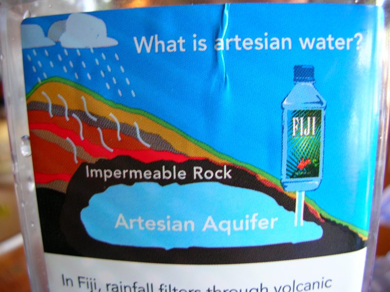
Numerous bloggers (most recently, the folks at Boing Boing) have noted the irony of FIJI Water's graphic describing the source of their artesian aquifer water, which sits contentedly below a layer of "Impermeable Rock" while rain pours down generously from the Fijian sky.
Basically, the geologic graphic this company created to promote their product is confusing because it employs a confusingly "cyclical" design trope common to water-cycle diagrams to show something that is not cyclical at all. To make matters worse, they throw a bit of misinformation into the mix.
The Idaho Department of Environmental Water Quality describes several types of aquifers, the most basic being:
- Confined—An aquifer overlain by one or more layers of impermeable rock or soil that restrict water to within the aquifer. The water is confined under pressure. Drilling a well into a confined aquifer releases that pressure and causes the water to rise in the well. These wells are sometimes called artesian wells.
- Unconfined—An aquifer that is not overlain by a layer of impermeable rock or soil. Water in a well will naturally stay at the level of the water table. As water is removed from the well, the water table at that place is lowered, causing the surrounding ground water to flow toward the well.
Here is a University of Georgia graphic showing confined and unconfined aquifers:
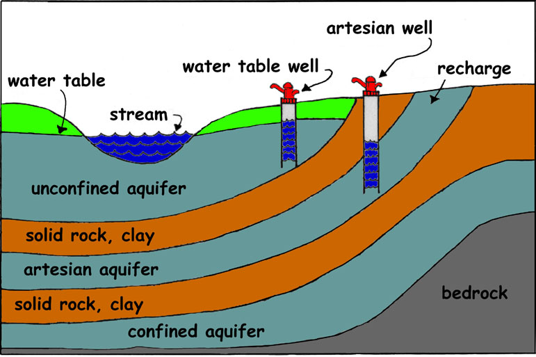
A confined aquifer, which technically is "locked out" of the water table by impermeable rock, does not have a recharge zone and thus does store a theoretically limited supply of water. This confinement can be caused by an impermeable layer of rock being laid down on top of an existing aquifer or part of the water table, dividing it from any porous area. Keep in mind that an aquifer itself is not usually an open space filled with water, but a highly permeable layer like gravel, silt, etc. that is saturated with water, and this starts to look a little more plausible.
But there are serious problems with FIJI's campaign. As their own website declares:
By definition, artesian water comes from a source deep within the earth, protected by layers of clay and rock. There is no opening, not even a porthole to the surface. As a result, the water never comes into contact with the air, protecting it from environmental pollutants and other contamination.Whoops! In fact, an artesian aquifer may be confined, or unconfined, as the above UGa graphic makes clear. Many others seem to get this wrong too. (Wikipedia exhibits a problem only Wikipedia can boast of, that of contradicting itself - a nice graphic clearly shows an unconfined artesian aquifer, but the first line of the entry that links to it defines artesian aquifers as confined.) To cite one of many definitive counterexamples, the U.S. Geologic Survey describes an artesian aquifer in New Mexico thusly:
Recharge to the artesian aquifer of the Roswell Basin occurs over a broad region east of the Sacramento Mountains known as the Pecos Slope where geologic units containing the artesian aquifer are exposed at land surface. Discharge from the artesian aquifer into sinkholes supports critical habitat for endangered species at the Bitter Lakes National Wildlife Refuge.Of course, Wikipedia's entry can be corrected in about five minutes. (Got five minutes?) But when will FIJI fix their water bottle labels? And does FIJI's error mean that they don't know what an artesian aquifer is, or that theirs may not be confined?
But the biggest source of confusion over FIJI's graphic is that they show rain falling on the area and the aquifer underneath it. This immediately suggests, as it should, that the water is recharging the aquifer. It is possible that their diagram is intended to show that the water was introduced to the area at an early stage, followed by the introduction of a lava flow that turned into a layer of igneous rock. If so, there is something truly medieval about the way this graphic collapses real time into a single image without any reference to time's passage. It is more likely that they included the rain to show how it does not penetrate into the aquifer, but it seems more likely that it deserves all of the scorn it is receiving. It is a very confusing graphic.
So, long story short, such things do exist, even if FIJI doesn't explain them very well.
A few design changes could have improved the situation. The folks at FIJI could have:
- Included a graphic showing how the impermeable layer is laid down;
- included a magnified view showing how difficult it is for water molecules to navigate their way through the mineral grains of an "impermeable" rock; or, most importantly,
- added an unconfined aquifer above the impermeable layer (the most common real scenario anyway) to show where the rain actually goes, and to highlight the distinction between a confined source and an unconfined one.
![]()


No comments:
Post a Comment